Madagascar Completes Landmark Marine Biodiversity Assessment, Laying the Foundation to Exceed its 30×30 Marine Target
Malagasy institutions identify 425,000 km² of priority marine areas - 25% more than Madagascar's 30x30 target requires
Press Release Disclaimer: This is a press release distributed through the XPR Media network. It has not been independently verified by our newsroom.
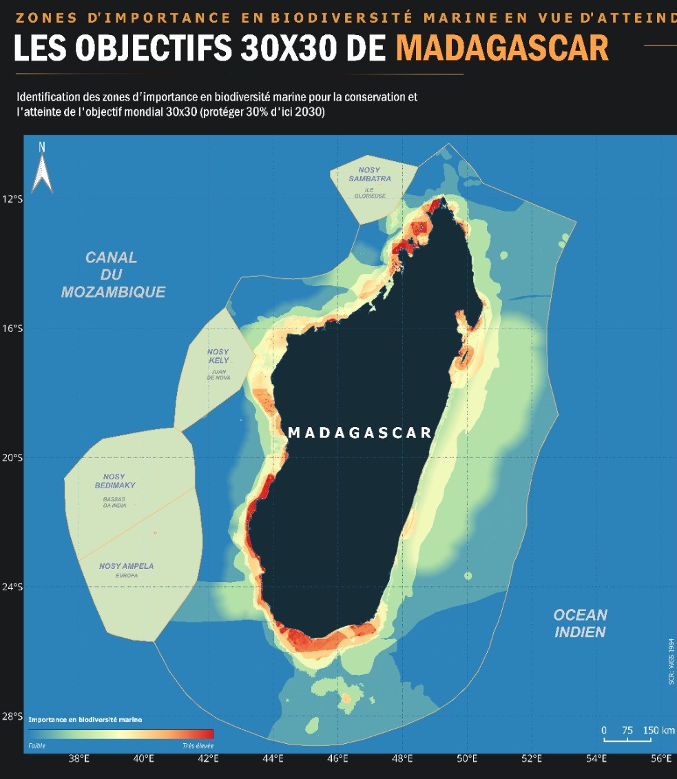

Malagasy institutions identify 425,000 km² of priority marine areas – 25% more than Madagascar’s 30×30 target requires – paving the way for lasting protection.
ANTANANARIVO, MALAYSIA, September 21, 2026 /EINPresswire.com/ — ANTANANARIVO – Madagascar has completed the first comprehensive national scientific assessment of marine biodiversity priorities within its Exclusive Economic Zone, delivering the scientific foundation for the marine component of the country’s 30×30 Biodiversity Plan. The report (Identification of Sites of Importance for Marine Biodiversity, In Support of Madagascar 30×30) led by the National Oceanographic Data Centre (CNDO) at the University of Toliara’s Institute of Fisheries and Marine Sciences (IHSM), identified 425,000 km2 of priority marine and coastal areas across Madagascar’s 1.14 million km² Exclusive Economic Zone – more than the country’s 30×30 target requires, giving national authorities scientifically-grounded flexibility to design one of the most rigorous marine conservation networks in the region.
The marine assessment is the companion to Madagascar’s terrestrial biodiversity re-prioritization completed in March 2026 – the first such exercise for the country since 1995. Together, the two workshops give Madagascar a unified scientific foundation for its entire 30×30 commitment, covering both land and sea. Few countries have completed rigorous, nationally-owned scientific prioritization for both terrestrial and marine biodiversity at this scale.
While Madagascar’s terrestrial biodiversity is world-renowned for its lemurs, baobabs, chameleons and other species found nowhere else on Earth, this island nation lies in the Western Indian Ocean at the heart of one of the most biologically rich and evolutionarily unique marine regions in the world. Its waters host coral reefs, mangroves that buffer coastlines and store carbon, seagrass beds, humpback whale migration routes, endemic reef fish, sea turtles, dugongs, sharks, and rays. Coastal fisheries sustain the livelihoods and food security of millions of Malagasy people, and yet marine protection in Madagascar has historically lagged far behind terrestrial protection. This assessment bridges that gap and provides a clear, aligned path forward for effective marine protection.
The marine assessment analysed 18 geospatial data layers – covering biodiversity, critical habitats, existing governance, and socio-economic uses. The results were validated on 19 May 2026 in Antananarivo by 43 institutional, scientific, and civil-society representatives drawn primarily from Malagasy institutions including MEDD (Ministry of Environment and Sustainable Development), MPEB (Ministry of Fisheries and Blue Economy), MATSF (Ministry of Land Use Planning), IHSM, the National Institute of Oceanographic Research (CNRO), the MIHARI network of locally managed marine areas, Madagascar National Parks, Hay Riake national marine governance NGO alongside in-country teams from WCS, WWF, IUCN, Blue Ventures, and CI.
The priority zones are concentrated along Madagascar’s northern and western coasts, around key island formations including Nosy Be and the Radama archipelago, and on the seamounts of the Malagasy plateau. The findings align closely with internationally recognised marine priority frameworks – including Ecologically or Biologically Significant Marine Areas (EBSAs), Key Biodiversity Areas, Important Marine Mammal Areas, and Important Shark and Ray Areas – providing cross-validation for the national process.
“For the first time, Madagascar has a single, scientifically grounded national reference for marine biodiversity – built from 18 data layers, validated by 43 experts from across our national institutions, and rooted in the guiding principle that we do not protect what we do not know,” said Ny Aina Andrianarivelo, Marine Expert at the 30×30 Coordination Unit and lead author of the report. “This is the foundation on which Madagascar’s marine conservation will be built, and over the most consequential decade for conservation.”
Workshop participants introduced a fifth prioritization criterion, “Gaps and Opportunities,” specifically to account for deep-sea areas and seamounts that remain scientifically undocumented. This mirrors a finding from the March 2026 terrestrial workshop – that in one of the world’s most biodiverse countries, some of the highest-priority areas are also the least understood, and require dedicated field research over the years ahead.
“The marine and terrestrial workshops together give Madagascar something few countries have – a unified scientific foundation for our entire 30×30 commitment,” said Alain Liva Raharijaona, 30×30 Coordinator at Madagascar’s Ministry of Environment and Sustainable Development. “We now know, with rigour, where our biodiversity is concentrated on land and at sea. The next step is turning that knowledge into designated areas, effective management, and long-term financing – and doing so with the communities who steward these ecosystems every day.”
The assessment is already in motion: formal MEDD-MPEB endorsement was achieved in July 2026, with the first new Marine Protected Areas in the Excellent and Very High priority zones expected by the end of this year, and management plans developed through 2027. The 425,000 km² of identified priority marine areas exceeds the 30% target of 342,000 km², meaning national authorities will select the sites offering the best balance of biodiversity value, governance feasibility, and compatibility with existing uses, including small-scale fisheries.
“Madagascar’s 30×30 plan was not built for our communities but with them, because the stark reality is that millions of Malagasy people depend on our country’s forests, coasts, and waters not just for their livelihoods but for their survival,” said Gildas Todinanahary, Director of IHSM which hosts the National Oceanographic Data Center (CNDO). “This marine assessment, coming after the terrestrial one earlier this year, gives us the confidence to move forward knowing that protection is grounded in science, shaped by the people who know these ecosystems best, and designed to safeguard our natural heritage – for our people, and for the planet.”
This marine assessment is the latest milestone in Madagascar’s 30×30 Biodiversity Plan – a nationally-owned, science-based, and costed strategy to protect 30% of the country’s land and ocean by 2030. Since February 2026, Madagascar has designated 21 new terrestrial and marine protected areas covering 1.82 million hectares, completed comprehensive scientific prioritization exercises for both its terrestrial and marine biodiversity, and secured the Prime Minister’s formal commitment before international partners in Washington DC in April 2026.
About Madagascar’s 30×30 Biodiversity Plan
Madagascar’s 30×30 Biodiversity Plan is a nationally-owned, science-based, and costed strategy to protect 30% of the country’s terrestrial and marine areas by 2030. In February 2026, Madagascar designated 21 new protected areas covering 1.82 million hectares, bringing the national total to 8.88 million hectares. The plan targets 18 million hectares of terrestrial and 40 million hectares of marine ecosystems under strengthened protection by 2030. It is supported by SPACES, Campaign for Nature, the High Ambition Coalition for Nature and People (HAC), Rainforest Trust, Re:wild, the Hempel Foundation, Conservation Allies, and international partners including KfW, AFD, and the World Bank. www.madagascar30x30.com
Sarah Killian
Campaign for Nature
email us here
Legal Disclaimer:
EIN Presswire provides this news content “as is” without warranty of any kind. We do not accept any responsibility or liability
for the accuracy, content, images, videos, licenses, completeness, legality, or reliability of the information contained in this
article. If you have any complaints or copyright issues related to this article, kindly contact the author above.

Media gallery